This page is also available as a PDF download.
At 22 January 2021 a new download page was added to iRecord, under the Explore menu. This should provide faster downloads and does away with the previous limitations on how many records can be downloaded at once. It also introduces a new option for downloading records in a “Simple download format” that contains fewer columns than our previous download. The previous format is still available for those wanting to include a wider range of detail for each record, via the “Standard download format”.
Page controls
- Records to access: this allows you to select your own records (“My records”) to download, and if you have participated in iRecord Activities, or if you have a verification role or other assigned role you will be able to select that and download the relevant records.
- Custom filters: if you have created and saved any custom filters (via the “Create a filter” button, either on this page or on the Eplore pages) you can select them here. (Filters created by verifiers on their verification page are not available here.)
- Record status included: allows you to choose which records to include based on whether or not they have been verified or queried etc.
- Download single survey: some of the recording forms that can be used to add records contain additional fields (“custom attributes”) that only apply to that survey. If you have used one of these forms and wish to download your records with all the extra fields included, you should choose the survey that you need and then download it. Your download will include all the usual columns plus and additional custom ones.
- Create a filter: if you click on this button you will be able to use the same set of filter settings that can be found on the Explore pages. This allows you to add further restrictions to the set of records you want to download. For example, you can restrict the download to a particular species, vice-county or time period.
- “Filter summary” box: this provides a summary of all the choices you have using the various filters, so that you can check you have the correct set of records specified before downloading them.
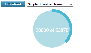
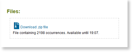
Below this, you will see the “Download” button, and next to that you can choose whether to download the “Simple download format” or the “Standard download format”. When you click on “Download” the progress wheel will show you the records being generated, and when complete you will be given a link to “Download .zip file”. Click on that link and save your records.
The .zip file contains a .csv that can be extracted from the .zip file, and then opened into a spreadsheet or database. If you have spreadsheet software on your computer you will probably find that you can double-click on the .csv file and it will open as a spreadsheet. Alternatively you can open your spreadsheet software first and import the .csv file as a text file.
File contents: Simple download format
This file format has been developed in response to requests from some users who wish to download their records and bring them into the MapMate standalone database, and the first 13 columns (column A, “Taxon”, through to column M, “Comment”) have been set to match as closely as possible to the format that MapMate requires. The subsequent columns (N to X) contain additional information that may be needed to understand or filter the records before choosing which ones to make use of.
Please note that this is a cut-down version of the full range of data stored in iRecord, and if you need the additional details you should use the Standard download format.
The columns (attributes) that match to MapMate are:
- Taxon: this is usually a species name, but may be a subspecies, genus or family etc. If you wish to filter out any of these other taxa use the “Rank” column (see below). Taxon names are taken from the UK Species Inventory and may not always match the names in MapMate
- Site*
- Gridref: this will contain a grid reference wherever possible, but in some circumstances (e.g. where a record is far offshore) a latitude and longitude may be given
- VC: the vice-county number; if a grid reference crosses more than one vice-county this will be set to zero
- Recorder*: the person who record the observation
- Determiner*: the person who identified the species (often it is the recorder who identified the species, but if someone else provided the identification they may be given as the determiner)
- Date: date ranges are formatted into one column
- Quantity: this column only contain integer numbers; if the iRecord record does not have a numeric value this column will contain a zero, following a MapMate convention whereby zero means “Present but not counted”. See also “NonNumericQuantity” below.
- Method*
- Sex: m = male, f = female, g = mixed group, u = unrecorded
- Stage: Adult, Larva etc.; this column may contain terms that are not recognised by MapMate
- Status: this attribute is not generally used in iRecord, hence this column is populated with “not recorded”
- Comment: will contain any text from the iRecord “Occurrence Comment” and “Sample Comment”, and will always end with the iRecord unique identifier (RecordKey) so that records can be traced back to their originals on iRecord if needed
* = in this Simple download format, Site, Recorder, Determiner and Method are all truncated if they are longer than 62 characters, in order to be compatible with MapMate limitations. If you need the full versions of these fields please use the Standard download format.
These additional columns are provide for filtering and for use in other systems:
- RecordKey: the iRecord unique identifier
- Common name: the vernacular name from the UK Species Inventory
- Source: the website and survey that the record originated from
- NonNumericQuantity: many iRecord surveys allow quantities to be recorded as words or numbers, and any non-numeric quantities information is included in this column
- Input on date: date the record was added to the data warehouse
- Last edited on date
- Verification status 1: Accepted, Rejected or Unconfirmed
- Verification status 2: Correct, Considered correct, Unable to verify, Incorrect, Not reviewed, or Plausible
- Query: indicates a record that has been queried by a verifier
- Licence: records added directly to iRecord are shared as described in our Terms of use, but some record sources that contribute records into the data warehouse apply record-level licences to the records; these will either be Creative Commons licences or in some cases an Open Government licence may be applied; record users should respect the terms of these licences
- Verified by: name of the verifier who has reviewed the record
- Rank: shows whether the taxon name is for a species, subspecies, genus etc.
File contents: Standard download format
This file format is almost identical to the previous csv output from the old download page.
- ID: the numeric part of the RecordKey
- RecordKey: the full RecordKey
- External key: if the record has originated from an external database or app it may have a unique identifier imported from the originating system
- Source: the website and survey that the record originated from
- Rank: the level of this taxon in the taxonomic hierarchy (species, genus, subspecies etc.)
- Species: the scientific name from the UK Species Inventory
- Common name: the vernacular name from the UK Species Inventory
- Taxon group: the “informal taxon group” from the UK Species Inventory
- Kingdom
- Order
- Family
- TaxonVersionKey: a unique identifier for the taxon name, from the UK Species Inventory
- Site name
- Original map ref: the geolocation as originally entered
- Latitude: this and the next columns provide the geolocation as decimal lat/long coordinates
- Longitude
- Projection (input): the projection associated with the Original map ref
- Precision: the precision of the grid ref used, or the precision captured by an app GPS
- Output map ref: the geolocation converted to a grid reference where this is possible
- Projection (output): the projection associated with the Output map ref
- Biotope: any habitat term that has been captured
- VC number: the vice-county number; if a grid reference crosses more than one vice-county multiple numbers will be listed
- Vice County: the vice-county name; if a grid reference crosses more than one vice-county multiple names will be listed
- Date interpreted: a single-column date that will include date ranges if applicable
- Date from: the date on which a record was made, or the first date of any date range
- Date to: will either be equal to Date from or will be the end date of a date range
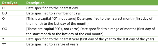
Date type: the type of date range
- Sample method
- Recorder: the person who record the observation
- Determiner: the person who identified the species (often it is the recorder who identified the species, but if someone else provided the identification they may be given as the determiner); elsewhere in iRecord this field is labelled “Identified By”
- Recorder certainty: some recording forms ask recorders to state how certain they were of the identification
- Sex
- Stage
- Count of sex or stage: may be an integer or a text description of abundance
- Zero abundance: some recording forms allow records of absence to be made, that is the species was looked for but not found; if a record is one of absence then this column will have “TRUE”, otherwise it will show “FALSE”
- Comment: any comment attached to the individual record (Occurrence comment)
- Sample comment: any comment attached to the sample, which may consist of a group of records
Images: if an image (or other media file) is attached the record there will be an entry in this column; each entry consist of three elements, separated by semi-colons:
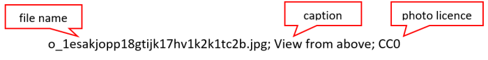
Most media files can be viewed by prefixing their file name with “https://warehouse1.indicia.org.uk/upload/” - the above example would be:
https://warehouse1.indicia.org.uk/upload/o_1esakjopp18gtijk17hv1k2k1tc2b.jpg
If there is more than one media file they will be listed, with each entry separated by a pipe: |
- Input on date: date the record was added to the data warehouse
- Last edited on date
- Verification status 1: Accepted, Rejected or Unconfirmed
- Verification status 2: Correct, Considered correct, Unable to verify, Incorrect, Not reviewed, or Plausible
- Query: indicates a record that has been queried by a verifier
- Verifier: name of the verifier who has reviewed the record
- Verified on
- Licence: records added directly to iRecord are shared as described in our Terms of use, but some record sources that contribute records into the data warehouse apply record-level licences to the records; these will either be Creative Commons licences or in some cases an Open Government licence may be applied; record users should respect the terms of these licences
- Automated checks: if the automatic checks have flagged a record as being hard to identify, out of range and/or at an unusual time of year this column will display “Failed checks”; if the record has passed all check, OR if there are no checks available for this species, this column will display “Passed checks”